Tuggerah Lakes and The Entrance Channel Update
Published On
11/05/2023Planned work at The Entrance Channel
Council is commencing a program of proactive works to strategically move sand from the sand spit at The Entrance channel to renourish the eroded northern foreshores of Karagi Point Reserve.
The program will include some berm height lowering of the Karagi Sandspit and take advantage of the opportunity to effect these works whilst the critically endangered Little Terns are in the northern hemisphere for our winter.
These works will improve access and help protect the amenity and foreshore infrastructure at Karagi Reserve carpark. Importantly the works will also reduce the amount of sand needing to be moved from the sand spit by Council (in accordance with the Interim Entrance Management Procedure) should flood mitigation works be required this winter.
What’s the current status of The Entrance channel?
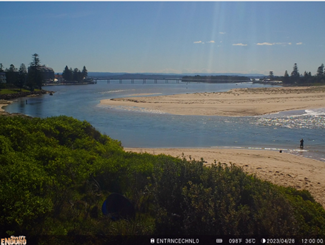
Through active monitoring of aerial and satellite imagery and the tidal gauge at The Entrance, the condition of the channel currently remains open with water flowing between the estuary and the ocean – however it is classified as heavily constricted.
A fully closed channel is a different classification altogether, which would trigger a different response to that required for the channel’s current condition.
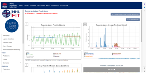
If the channel is heavily constricted it does not warrant immediate action, but does mean that Council will manage the berm in the event that a flood of 1.3m AHD or higher is predicted through our Manly Hydraulics Laboratory Flood Intelligence Tool (MHLFIT). There is currently no indication of the lake height reaching or exceeding 1.3m AHD, or even the minor flood level of 0.9m AHD and therefore berm intervention is not required at this time.

Benefits of constricted channel for the estuary
There’s a natural movement in the height of the water within Tuggerah Lakes, which supports the health of the estuary.
Estuaries such as Tuggerah Lakes with intermittent entrances are extremely dynamic and changes to channel conditions are a natural process. The recent constriction of the channel can be attributed to mild wave conditions and lower rainfall in the catchment.
When The Entrance channel is in a more constricted state, water levels in Tuggerah Lakes tend to be slightly higher on average.
This natural variation in water levels is an important process that can improve water quality and amenity. The higher water levels immerse the lake’s fringing wetland habitats, assist with the distribution of wrack and improve mixing of the water between shallow nearshore areas and deeper parts of the lakes. The fluctuations in lake levels also help to free and lift wrack that can get trapped near the shoreline, and place it in areas where it can aerobically break down (such as saltmarshes, fringing wetlands, and foreshore reserve areas), reducing odour.
How does Council monitor Tuggerah Lakes and The Entrance?
Council actively monitors the condition of Tuggerah Lakes and other coastal lagoons including The Entrance channel and uses the Manly Hydraulics Laboratory Flood Intelligence Tool (MHLFIT), which helps guide when Council intervention is required in order to mitigate the risk of flooding. Council also uses a gauge at The Entrance Bridge to provide a quantifiable measure of the influence of ocean tides on the estuary, and subsequently how constricted the channel is. So channel constriction is not just measured through visual observation.
Our coastal lagoons, are opened when water levels reach a trigger level, and when the lagoons are closed. This is a similar approach to that taken in other coastal local government areas.
For Tuggerah Lakes, our procedure is more unique and complex. Unlike the other coastal lagoons, Council may intervene in its management of the channel before it is closed and when water levels are predicted rather than reached.
MHLFIT uses Bureau of Meteorology predicted rainfall data to forecast potential lake levels up to three days before they occur, so Council intervenes at an earlier point in the process. This management approach is documented in the Tuggerah Lakes Interim Entrance Management Procedure – which prescribes actions to be undertaken that are tailored to different entrance conditions. Works may include berm scraping (reducing the height of the sand), pilot channels (creating a narrow channel with heavy machinery to create a second opening that will naturally widen) and emergency openings (in the unlikely situation of a completely closed channel).
Council is currently working towards the development of an Entrance Management Strategy through the Tuggerah Lakes Coastal Management Program. Interested community members can register their interest in staying up to date with news and opportunities to be involved.
Council’s procedure for managing The Entrance Channel can be found within the Tuggerah Lakes Entrance Management Study.

Can Council prevent flooding of Tuggerah Lakes through dredging, berm management, or other intervention at The Entrance Channel?
No. The foreshore of Tuggerah Lakes is and always will be flood prone.
The minor flood level for Tuggerah Lakes is just 0.9m AHD, which is the level at which some roads start to be flooded.
Statistically there is about a 50% chance of at least this level of flooding each year. Over the past 100 years there has been flooding in the lake up to 2.1m AHD (in June 1949); there have been six floods higher than 1.7m AHD, including the July 2022 flood, which was the sixth highest at 1.72m AHD.
Council estimates that the largest flood that could conceivably occur – called the Probable Maximum Flood – could reach 2.7m AHD. This also happens to be the minimum floor level that Council has been setting for habitable areas of residential buildings around the lake over the past 40 years.
Tuggerah Lakes is generally just above average sea level (which is approximately 0m AHD); it is normally in the range of about 0.2m AHD to 0.4m AHD. Generally, if there is about 200mm of rain then the lake level can slowly rise about 0.6m over about three or four days to a minor flood level of 1.3m AHD. With about 350mm of rain, lake water level can even further over this timeframe and can result in major flooding of 1.6m AHD. Note that these levels are still not very much higher than mean sea level; which is because the lakes are very large, so the flood waters can spread over a large area.
Let’s put this into perspective: in comparison to Tuggerah Lakes the high tide level at other locations on the Central Coast, such as Woy Woy in Brisbane Water or Spencer on the Hawkesbury River can be up to 1.2m AHD, even on a sunny day with no rain, as the tidal range is larger, more like the open ocean at these locations. These sunny day levels are 0.2m higher than a minor flood level in Tuggerah Lake. The Central Coast also has some other coastal lagoons, which are much smaller versions of Tuggerah Lakes. These are all perched up above normal mean sea level. Terrigal Lagoon is the lowest of these. and Council attempts to open Terrigal Lagoon when it reaches 1.23m AHD. Sometimes Council may have to wait longer to successfully open Terrigal lagoon depending on the ocean conditions: wave runup, especially at high tide, can keep filling the channel back up with sand. The other coastal lagoons have higher let-out levels: Avoca at 2.09m AHD, Wamberal at 2.40m AHD, and Cockrone at 2.53m AHD. These lagoons are much easier to successfully open because of the increased energy of water running out of the lagoon from a higher level, which can quickly cause the pilot channel to widen, overcome the wave action, and allow the lagoon level to recede.
Unlike these coastal lagoons, which are predominately closed, Tuggerah Lakes is predominately open (the last time it completely closed was in 1987). If there is likely to be a flood in Tuggerah Lakes, then Council has an adopted procedure to help sand at The Entrance Channel to be better able to scour away so that the channel can gradually widen to let out more floodwater. But like Terrigal Lagoon, it can be very difficult to get the entrance to start naturally widening further until the lake level gets to at least 1.3m AHD. At lower levels there is simply not enough energy in the flowing water for sand to scour away to allow the channel to naturally widen.